Changing your name in Google Talk
Posted by Wesley on
Okay, I think I got this asked enough times (I already have 52 people in my GT contacts list) so I think it merits an explanation. It's still a bit clunky, and yes I really hope Google Talk gets this streamlined in the final version, but since a lot of us are using it anyway, let's see... how to change your screen name on Google Talk! You can also do this without affecting your Gmail account, and I'll cover that, too.
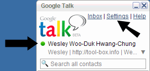
Okay, so you got this name from your Gmail account stuck on your Google Talk (left arrow). You want to go to 'Settings' first (right arrow).
Continue reading "Changing your name in Google Talk"
Okay, so you got this name from your Gmail account stuck on your Google Talk (left arrow). You want to go to 'Settings' first (right arrow).