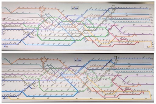
Comical patching of the Seoul subway map
Posted by Wesley onExtension of the Bundang Line in the Seoul metropolitan subway network will be complete in two days after a 5-year delay. This yellow-coloured line starts at Wangsimni station in the eastern Seoul and will extend to the south to Suwon station (currently 4 stations short at Mangpo station), while passing through Bundang district in Seongnam, which is where the name comes from.
Trouble is, this north-south line needs to be laid out horizontally on a super-wide line map pasted on top of the doors of the subway cars. Suwon station is already on Line 1, which is another line to go north-south, and this dark blue line is drawn from top right to bottom left. So the station sits at the bottom left corner of the map.
Meanwhile, Bundang line starts at around the middle and weaves towards bottom right on the maps installed in Seoul Metro (responsible for Lines 1 through 4) subway cars. In order for the line to meet up at Suwon station, it needs to make a sharp turn at the bottom and make a long run from right to left. Clearly, the map designer didn't think ahead, despite the plans for extension existing for a better part of a decade.
I thought this was a good time for the map to be overhauled. It already received several patches all over the place in the last couple of years. But no, Seoul Metro just put an incredibly long patch at the bottom of the map to connect Bundang line and Line 1, as you can see in the comparison picture. That's comically sad.
Defined tags for this entry: Bundang Line, subway
